The concept of a "new capital city" by the People's Party began in 1938 during the time when Field Marshal Plaek Phibunsongkhram (then holding the rank of Colonel) was Prime Minister. The People's Party considered Bangkok to be fraught with problems, from overcrowding and flooding to its unsuitable location, strategically speaking. Consequently, they began searching for a site to establish a new capital city, considering places like Lopburi, Ayutthaya, and Nakhon Sawan. In 1942, Saraburi Province was seriously considered. However, due to Thailand facing the Greater East Asia War and continuous bombing by Allied aircraft (as Thailand was an ally of the Axis powers), the plan to move the capital to Saraburi had to be suspended. Saraburi's geography, being a flat plain, made it susceptible to bombing just like Bangkok. The People's Party then decided to relocate the capital to a province surrounded by complex mountain terrains with better strategic advantages like Phetchabun Province instead. Although the capital relocation project ultimately did not materialize, the legacy of this grand project remains tangible to this day. This is evident not only in Phetchabun, where government office buildings had already begun construction at that time, but also in Saraburi, the former top-choice dream capital of the People's Party.
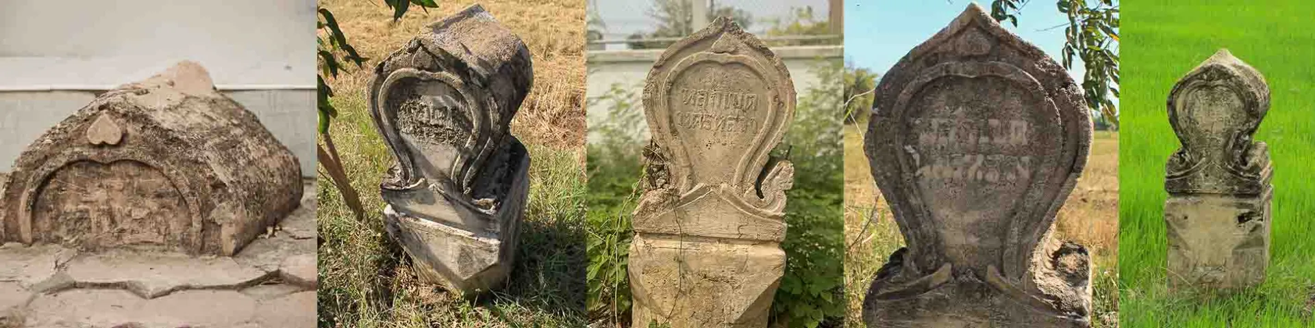
The boundary markers of the capital city are concrete markers shaped like sema leaves, standing approximately 1.50 meters above ground level, inscribed with the words "Boundary Marker of the Capital City." Currently, around 12 such markers have been found in the border area of Saraburi and Ayutthaya provinces. Studies indicate that these markers were used to delineate the boundary around the expropriated area for the construction of "Phutthaburi Monthon," the new capital city project in Saraburi Province. This is consistent with the document "Improvement and Establishment of the New Capital" in the National Archives, which records this capital relocation project in considerable detail, along with a map of the "Capital City Plan" created in 1942. The new capital city plan was rectangular, covering an area of 406 square kilometers. The northern border was adjacent to the mountain range where Wat Phra Phutthabat in Saraburi and Prachathipatai Road (Phaholyothin Road) are located. The western boundary was marked by the northern railway line, with three stations connecting to the city: Tha Ruea Station, Ban Mo Station, and Nong Don Station. The southern boundary was defined by the Pa Sak River, while the eastern boundary was along Prachathipatai Road. Thus, the new capital would be surrounded by complete transportation options, including rail, road, and water routes. The city's layout featured a grid pattern of roads, with diagonal roads intersecting at 45-degree angles, creating a spider-web-like network covering the entire city. The main axis running from north to south was believed to be designated as the central administrative area of the country, extending directly to the Phra Phutthabat Mondop in the north of the city, which was intended to be the "city pillar" according to Field Marshal Plaek Phibunsongkhram's concept. This city plan also reflected the modern urban planning knowledge that emerged clearly after the 1932 Revolution.
It is noteworthy that Wat Phra Phutthabat in Saraburi was a religious site given special importance by the People's Party and Field Marshal Plaek Phibunsongkhram. In 1933 (only one year after the change of government), the People's Party commissioned the Fine Arts Department to renovate the top of the Phra Phutthabat Mondop in a manner that resembled new construction. They later built the Phra Thinang Yen pavilion on an elevated base in front of the Mondop, in the modern "Thai architecture in concrete" style following the approach of the People's Party's architecture. In 1936, the government issued a royal decree designating the area around Phra Phutthabat and its vicinity as a restricted zone for the benefit of Buddhism. Eventually, in 1942, Field Marshal Plaek Phibunsongkhram designated Phra Phutthabat in Saraburi as the city pillar of the new capital, leading to the construction of boundary markers to delineate the city's borders. However, due to the government's change of plans to relocate the capital to Phetchabun, this legacy of the People's Party lost its significance. When the proposal for the royal decree to move the capital to Phetchabun was rejected by the People's Representative Council on July 20, 1944, Field Marshal Plaek Phibunsongkhram decided to resign as Prime Minister. Shortly after the end of World War II, the People's Party lost power, leaving behind only the boundary markers around their "new capital" that never materialized.